I've wanted to go to Septet Pass for a while since its in the old Invermere hiking book. It wasn't very high on my list until I went up a ridge next to it and saw the tarns on the bench above the lake. Then it moved up in importance, especially since the road is washing away. So even though the smoke was horrible and the forecast said it would only get mildly better, I headed out on my first free three day weekend of the summer.
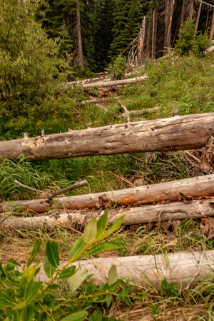
I don't know why I don't have photos until this point, but here there are 10(+) downed trees at the edge of an avalanche slope. This is the trail.
Before this the trail started out along a maintained trail for ~1.75km. This is because it shares the start with the trail to McLean Lake which is maintained by the Summit Trail Markers Society. Then you turn right and your on your own.
For 3.1km your hiking along what is initially an old overgrown road then later its just a trail. But its along the valley bottom parallelling Frances Creek. There are alders along the trail. 8 or 9 feet high but not overly thick. The kind you can bash away with your poles. Except for two ~50 meter long nearly impenetrable sections at the edges of avy paths. There were also downs of deadfall. Which is to be expected. I would guess at 50-60 downed trees. Then the most bear scat I've ever seen on a trail. A pile (fresh or otherwise) every 250m. So despite the alders this is a regular bear highway!